
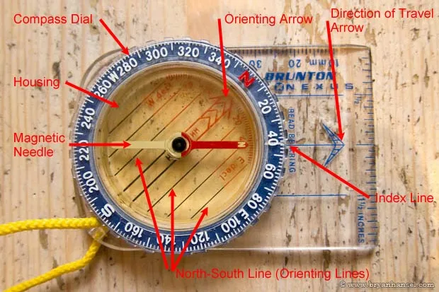
Parts of a Compass
Declination
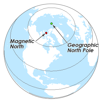
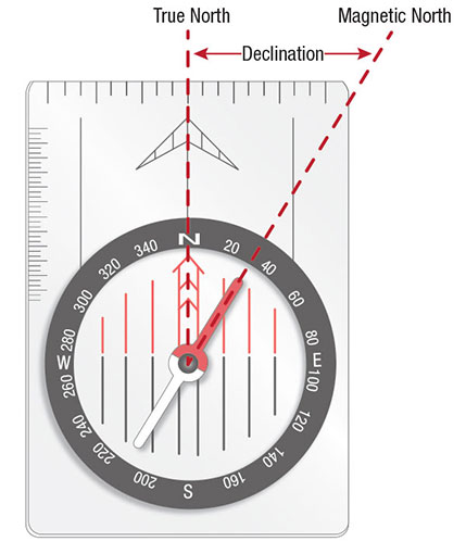
The north that is shown on maps is not the same as the north that the needle of a compass points to. Geographic north, also called true north, is based on where the lines of longitude converge in the north. This is also true for the south pole. These lines don’t move and are marked the same on all maps. However, a compass will point to magnetic north, not true north. Magnetic north is based on Earth’s magnetic field. Because Earth slowly changes every day, magnetic north has moved over the years. In fact, magnetic north has moved over 1000 kms in the past 150 years. This is why it’s important to note the year that a map was printed. Maps will show the declination, the difference between true north and magnetic north for the region, so a compass can be set to show true north. If the map is old, the declination could be outdated. The current declination can be found online. When the declination is set in the compass, the orienting arrow will point to magnetic north.
Taking a Bearing
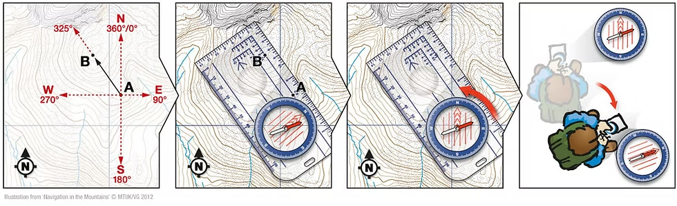
A bearing is a direction more specific than simply north or northwest that is expressed by an angle. This measurement can be used to travel in the direction to get to a specific location. To take a bearing, the straight edge of the compass is lined up on the map to connect where you are with where you want to go. The direction of travel arrow on the compass needs to be pointing to where you want to go. Next, turn the compass dial so the orienting lines in the center are lined up with north and south on the map. North on the compass dial will be pointing to north on the map. Then, read the number that the index line is at. Now when you hold the compass in your hand with the direction arrow pointing away from you and you turn so the magnetic north needle is in the orienting arrow (also called “red in the she”), you will be facing the correct direction you need to travel to arrive at your desired destination.
Finding Where You Are on a Map
But what if you don’t know where you are on the map? To find your location, look for landmarks around you that you can identify on the map, such a lake that you know the name of on the map. Hold your compass with the direction arrow pointing towards the landmark and turn the compass dial until “red is in the shed” or the needle is in the orienting arrow. The bearing can be read at the index line. Place the compass on the map with the straight edge lining up with the landmark with the direction of travel arrow pointing towards the landmark. Rotate the entire compass until the orienting lines are match the north and south on the map. Mark the line of the compass – you are somewhere along this line. If you want your exact location, take another bearing in the same manner at least 60 degrees different to use triangulation. The intersecting lines are your location. More bearings can be added to increase the accuracy.
Sample Lesson for Practice
This lesson provides students with the opportunity to practice following compass bearings without a map on school grounds. This could also be done in other defined areas, such as a camp ground.
Navigation Lesson Series
This document outlines a series of lessons that could be followed to develop students’ navigation skills, beyond just compass bearings.
References
Cowdrey, C. (2020, May 24). Compass Bearings: Navigation Techniques 2.4:. At the Edge Mountaineering. https://www.attheedgemountaineering.co.uk/post/navigation-techniques-compass-bearings
GISGeography. (2025, April 17). Magnetic North vs Geographic (true) North Pole. GIS Geography. https://gisgeography.com/magnetic-north-vs-geographic-true-pole/
Hansel, B. (2023, January 3). Parts of a Compass. PaddlingLight. https://www.paddlinglight.com/articles/parts-of-a-compass/
REI. (2016, December 20). How to Use a Compass || REI. YouTube. https://youtu.be/0cF0ovA3FtY?si=gEaxn4NSMEYv0Tyu
The Indiana Snowmobile Ed Course. (n.d.). Understanding declination. snowmobile-ed. https://www.snowmobile-ed.com/indiana/studyGuide/Understanding-Declination/501016_90632/
Leave a Reply